|
|
|
Hurricane Structure and Formation |
|
|
|
|
|
Hurricanes are tropical cyclones which have peak
winds about the central core (eye) that exceed 64 knots (74 mph). |
|
Other names: |
|
Typhoon (western N. Pacific) |
|
Baguio (Philippines) |
|
Cyclone (India and Australia) |
|
Tropical Cyclone (official name) |
|
|
|
|
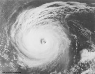
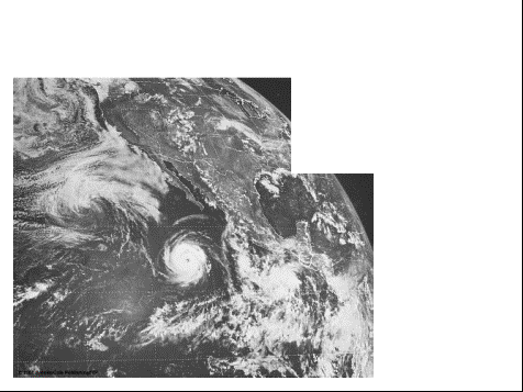
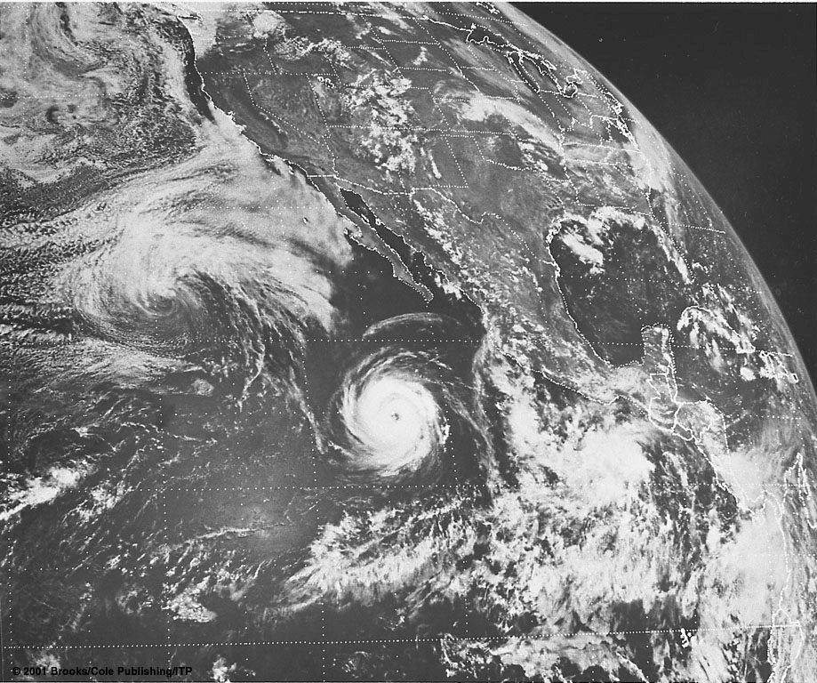
Hurricane John in Pacific. Central pressure is 965mb with sustained
winds of 100 knots near eye. |
|
|
|
|
Eye – winds light, clouds mainly broken, surface
air pressure is very low (here 965mb); diameter = 20-50 km typically |
|
Clouds align into spiraling bands (spiral rain
bands) |
|
Surface winds increase in speed as they blow
counterclockwise and inward toward the center. |
|
Wind and precipitation is most intense at the
eye wall. |
|
|
|
|
Going from west to east: |
|
Sky becomes overcast. |
|
Pressure drops slowly, then more rapidly. |
|
Winds blow from North or Northwest with
increasing speed. |
|
High winds generate huge waves (10m) and are
accompanied by heavy rain showers. |
|
|
|
|
As we move into the eye, the air temperature
rises, winds slacken, rainfall ceases, and the sky brightens (fewer
clouds). The barometer is now at
its lowest. |
|
Enter eastern side of eye wall. Heavy rain and strong southerly winds. |
|
Moving away from the eye wall, pressure rises,
winds diminish, rain diminishes, … as the process reverses. |
|
|
|
|
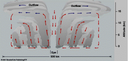
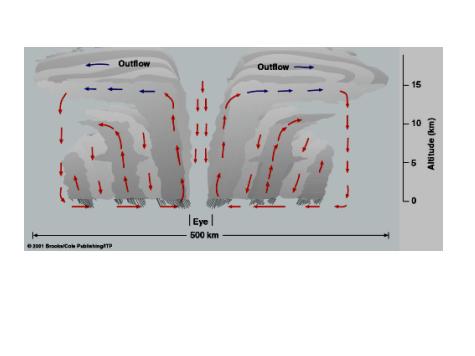
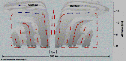
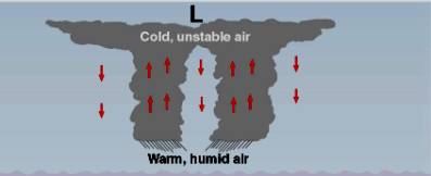
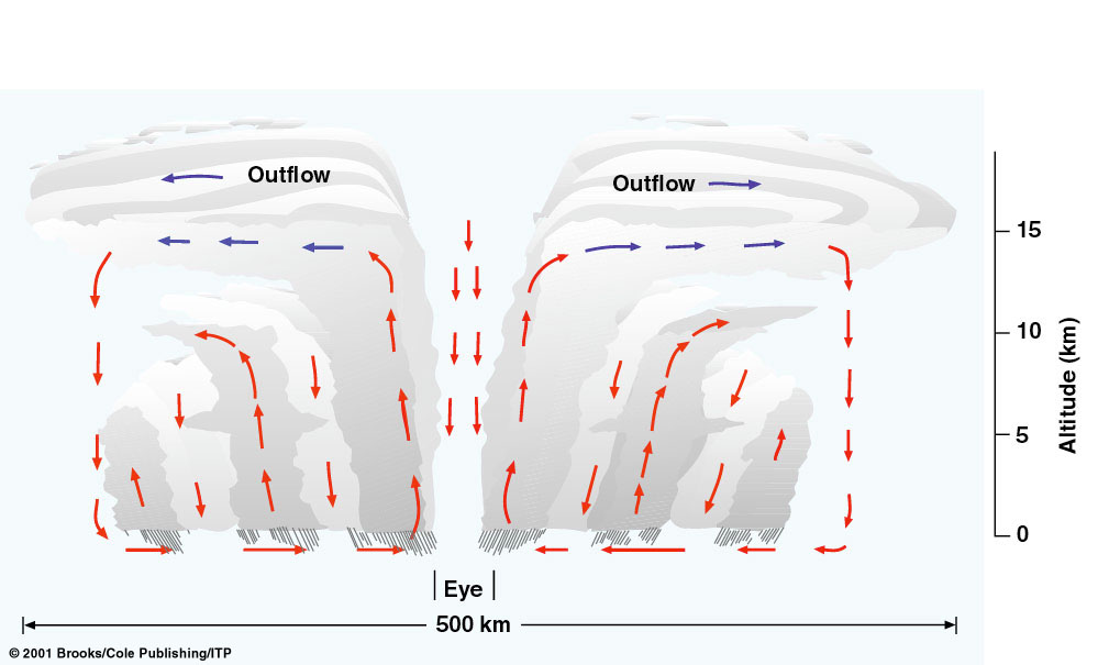
Organized mass of thunderstorms. |
|
Moist tropical air flows in to hurricane’s
center. |
|
Near eye, air rises & condenses into
thunderstorms. |
|
|
|
|
Near top of thunderstorms, dryer air flows
outward from the center (actually flows clockwise). |
|
At the storm’s edge, this air begins to sink and
warm, inducing clear skies. |
|
|
|
|
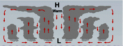
In the thunderstorms of the eye wall, the air
warms leading to higher pressures aloft and downflow in eye. |
|
Subsiding air warms by compression accounting
for the warm air and absence of thunderstorms in the eye. |
|
|
|
|
|
Hurricanes form over tropical waters where |
|
Winds are light |
|
Humidity high in a deep layer |
|
Surface water temperature is warm (80oF). |
|
Occurs in topical N. Atlantic and N. Pacific in
summer and early fall. |
|
Hurricane season normally runs from June through
November. |
|
|
|
|
In the tropics (between 23.5oN and
23.5oS) the noon sun is always high in sky. |
|
Coupled with high humidity this frequently leads
to development of cumulus clouds and thunderstorms. |
|
In some cases the thunderstorms may become
organized and form a hurricane. |
|
For that one needs convergence. |
|
|
|
|
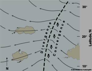
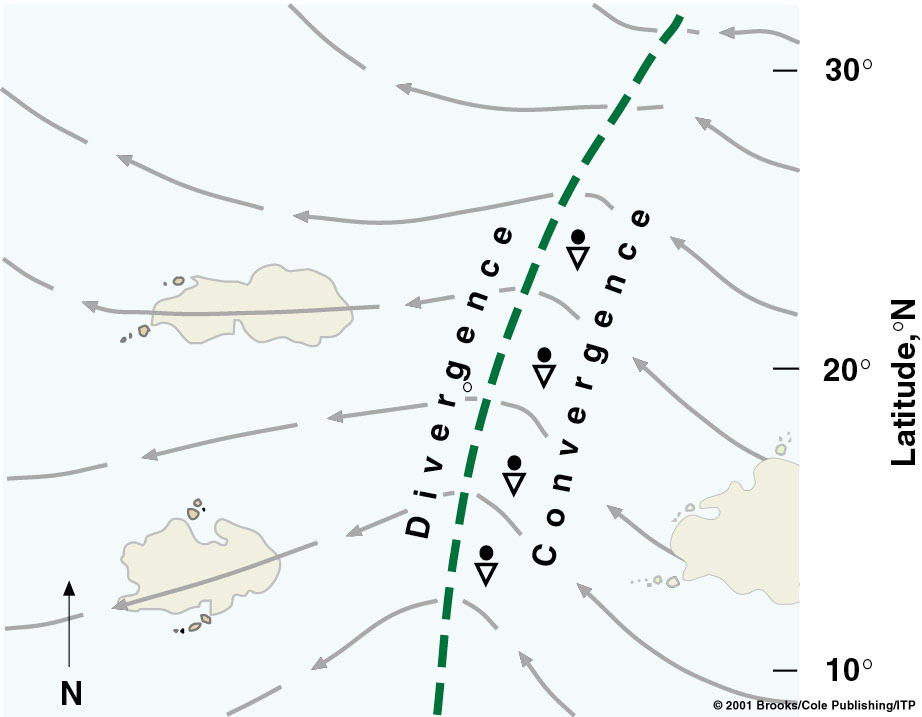
Sources of convergence: |
|
Intertropical convergence zone (ITCZ) – an area
of low pressure may develop along a wave in the ITCZ. |
|
Topical waves – converging and diverging region
in easterly winds in the tropics (common for Atlantic hurricanes). |
|
Front that moves into the tropics. |
|
|
|
|
Thunderstorms form in converging region. |
|
Typical wavelength 2500km and speed 10-20 knots. |
|
|
|
|
The converging air begins to spin
counterclockwise because of the Coriolis force. |
|
Can not happen right at the equator where
Coriolis force is zero. |
|
Two thirds of all hurricanes form between 10o
and 20o latitude. |
|
|
|
|
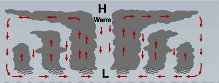
Need upper-level winds to diverge and leave more
quickly than surface air is converging (upper level air support). |
|
Trade wind inversion near 20o is
caused by sinking due to subtropical high (prevents). |
|
Hurricanes do not form when upper level winds
are strong and can disrupt the organization of the storm (occurs over
Atlantic more frequently in El Nino event). |
|
|
|
|
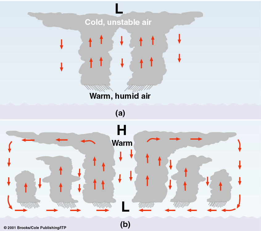
Suppose air aloft is unstable, e.g. colder. |
|
Large clouds are generated. |
|
|
|
|
Release of latent heat warms the upper level air
creating an upper level high. |
|
Upper-level winds move outward away from the
high enhancing surface low. |
|
|
|
|
|
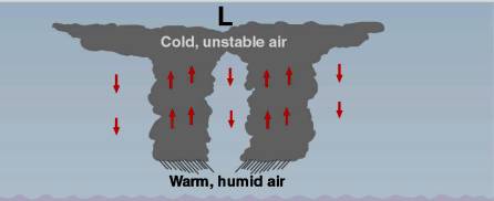
Chain reaction (feedback mechanism): |
|
Rising air releases more heat |
|
Increases surface low & upper level high |
|
Stronger surface winds |
|
More waves and friction |
|
Controlling factors are the temperature of the
water and the release of latent heat. |
|
When storm is full of thunderstorms, it has used
up all available energy. |
|
|
|
|
Heat engine -
heat is taken in at a high temperature, converted into work, and
then ejected at a lower temperature. |
|
For hurricanes source of heat is sensible heat
at surface and latent heat of condensation. |
|
Heat taken in at ocean surface, converted to
kinetic energy of wind motion, and lost at top due to radiation cooling. |
|
Not clear at present which theory (or both)
drives hurricanes. |
|
|
|
|
Tropical Disturbance – thunderstorms with only
slight wind circulation |
|
Tropical Depression – winds increase to between
20 and 34 knots. Several closed isobars appear. |
|
Tropical Storm – winds are between 35 and 64
knots. |
|
Hurricane – winds exceed 64 knots (74 mph). |
|
|
|
|
Tropical Storm |
|
Hurricane |
|
Tropical Depression |
|
Tropical Disturbance |
|
|
|
|
|
|
|
Some polar lows that develop over (relatively
warm) polar waters in the winter may have |
|
a symmetrical band of thunderstorms |
|
a cloud-free eye |
|
a warmer core of low pressure |
|
strong winds near the center. |
|
Some northeasters may have a cloud-free eye,
very strong winds, and a warm inner core. |
|
|
|
|
Hurricanes are tropical cyclones composed of
organized thunderstorms with winds about the eye exceeding 64 knots (74
mph). |
|
They derive their energy from warm tropical
water and latent heat of condensation. |
|
They form in a region of surface convergence and
upper level divergence. |
|

 Notes
Notes